- Screen Colours:
- Normal
- Black & Yellow
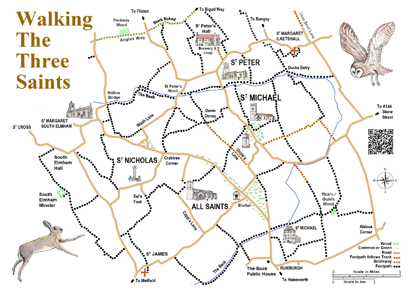
Walking the Three Saints Footpath Map - New Edition for 2026
DON’T GET LOST IN THE SAINTS!
To print off your free copy click: Walking the Three Saints Map
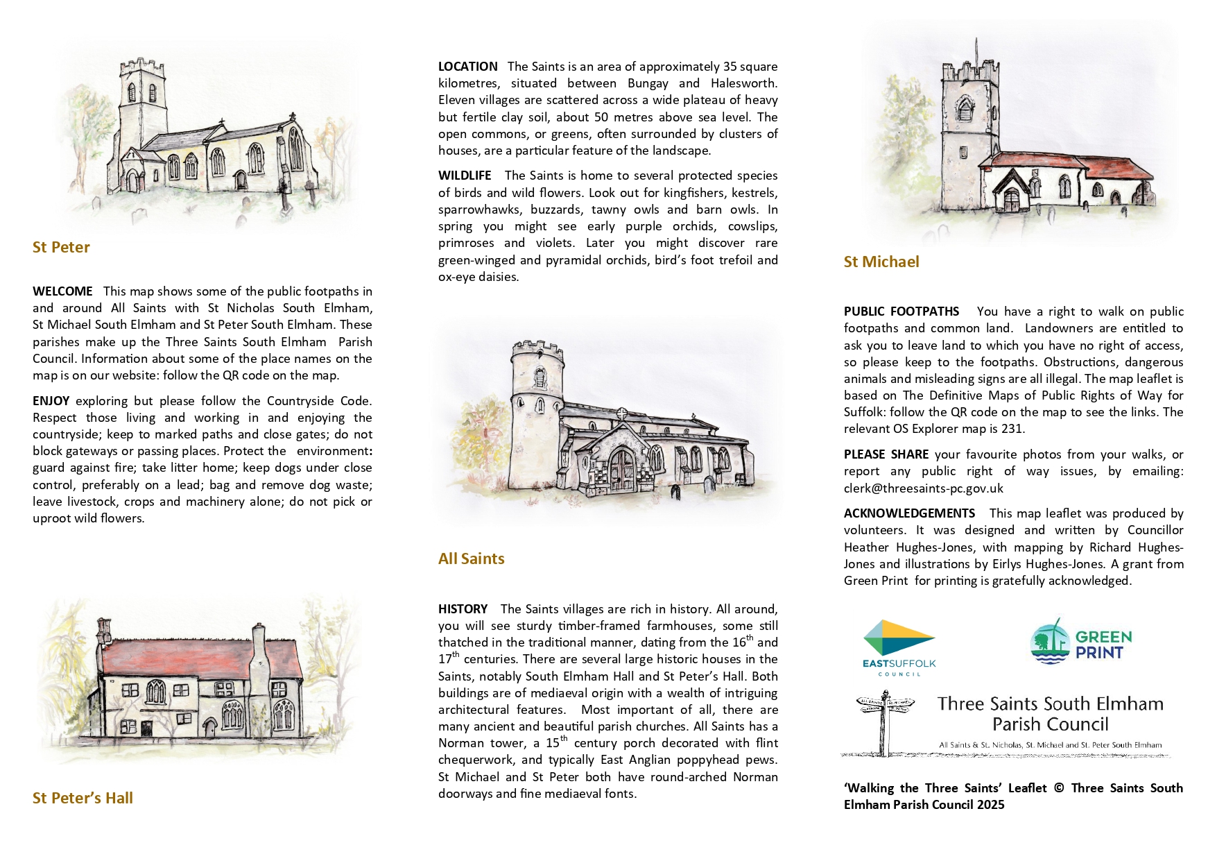
Walking the Three Saints’ is a footpath map based on the various Definitive Maps which cover the area of the Three Saints Parish Council. This leaflet, with its map and illustrations, has been created by volunteers. The public footpath walks have been checked but may be subject to change over time.
Click Views of The Saints to see photographs of interest found in the villages.
Walking the Three Saints Map Links
The Countryside Code - The Countryside Code - gov.uk
Reporting Issues with Rights of Way - Report any public right of way issues, by going to Report a public right of way issue - Suffolk County Council or emailing the Clerk at: clerk@threesaints-pc.gov.uk
The Definitive Maps of Public Rights of Way for Suffolk - Definitive Map and Statement of public rights of way - Suffolk County Council
Photo Gallery
Click Views of The Saints to see photographs from around the parishes.
Please Share your favourite photos from the walks by emailing the Clerk at: clerk@threesaints-pc.gov.uk and state where the photo was taken.
What's in a Name?
Glossary of Place Names on the map
Why is our area called the Saints? According to Harrold (2003) there 157 place names in England commemorating saints. Most of the 88 which are to local saints are in Cornwall. Of the remaining 69 in England, ten are in South Elmham and Ilketshall, giving us, as he says: ‘a rare concentration of saintly parishes’. The Saints is located between the rivers Blyth and Waveney near Bungay and Halesworth.
Aldous Corner
Aldous is a local surname. Ald is OE ‘old’.
All Saints South Elmham
Recorded as Ecclesia omnium Sanctorum in 1254 in the Norwich valuation tax document. In 1568 the name All Sayntes is recorded in an unpublished subsidy roll.
Angles Way
Angles Way is a 93 mile trail which follows the county boundary of Norfolk and Suffolk from Great Yarmouth to Thetford. The Angles were an ancient people living in this area https://www.norfolk.gov.uk/article/42921/About-Angles-Way-and-points-of-interest
Bungay
Listed in DB 1086 as Bongeia and Bunghea it is the Wangford Hd. Several derivations are possible but the second part ‘ay’ (OE e̅g) is probably ‘ land partly surrounded by water’. Some refer to it being the place at the island of dry or higher ground in a marshy area or an island in the bend of the river Waveney. The first part ‘Bun’ is more tricky. There is an OE personal name Buna but also ODan Bungi which means lump or swelling.
The Beck
Bek is ODan for stream. Bekkr is the Old Norse word for stream.
Capps Lane
Likely to be a family name. Capps can be of Norman origin or an occupational name of hat and cap makers.
Crabtree Corner
From the crab apple tree.
Down Doney
Du̅n OE for hill and denu OE meaning valley could indicate the dip where the farmhouse of that name once stood.
Ducks Entry
This likely descriptive of a waterfowl access route to wetland/fields.
Eel’s Foot
This is the site of a former eel farm. Eels were once an important source of income and a popular food. https://www.suffolkwildlifetrust.org/news/where-have-all-eels-gone
Flixton
Flixton is found as ‘Flixtuna’ in DB 1086. The main explanation is that Flixton derives from a personal name ODan of Flik, hence Flik’s tu̅n meaning Flik’s farmstead or estate. Another explanation is that the name relates to St Felix as a veneration and sign of ownership but maybe 100 years after his death. There is no evidence that St Felix visited, endowed or had any relics at Flixton. The lands were likely given to St Felix by King Sigebert and remained in the church’s ownership until well after the Norman Conquest.
Halesworth
In DB as Halesuuorda and Healesuurda. Part of the Blythyng Hd. The origin is probably from OE personal name Haele and worþ meaning enclosure thus Hæle's enclosure or homestead.
Hollow Bridge
Descriptive of a bridge at a hollow or low spot in the land
Hulver
Hulver, meaning holly, still survives in the East Anglian dialect. It derives from Old Norse and OE hulvere and there are numerous places names including Hulver Farm, Hulver Cottage in St Michael’s. Holly trees were pollarded and their branches used as forage.
Shoe Devil Lane
Many lanes in rural Suffolk historically acquired unusual names reflecting local tales or usage. “Devil” names often mark tricky land.
South Elmham
This is a place name which signals South Elmham’s important Saxon history. Harrold (2003) states that the first recorded use of the name was 12 October 803 in the Charter of Cloveshoh, where the Bishop of Elmham signed himself ‘Elmhamis Aecclesiae Episcopus’ and also appears in DB as Almeham. Elm Is OE for elm tree and is a common name prefix. Ham is OE for village, hamlet, estate or dwelling. This explanation is the simplest but there others given in Harrold (2003).
Stark Naked
Name of track and farm known as Sternacre but became changed in general speech to Stark Naked. Derivation is from stern meaning hard, severe or harsh and æcer OE for a plot or strip of land- acre.
Stone Street
This is a Roman road between Bungay and Halesworth still traceable on maps. Literally a street made of stone. OE stān means stone. The name Stone Street is an indication that it follows the line of a Roman highway. http://www.ilketshallstandrew.com/history.html
Tinks/ Gules Wood
Nicholas Battle of Rumburgh", in a will dated 24 August 1539, left his son Edmund Battely a "Ten[emen]t called Abbotts, Paynes and Gooles". Gooles is located near Rumburgh Wood, just over the parish boundary in St. Michael South Elmham. Edmund Battely’s will was dated 1565 and named his wife Agnes (who he leaves his "landes Tenemente and hereditamente called Gules") and sons Nicholas, George (who he leaves a close called Warplockes in South Elmham) and Thomas, his sister Johanna and her son Nicholas, his sister Margaret and cousin John Candler. His burial in Rumburgh in June 1565 was recorded in the parish registers. https://www.wikitree.com/wiki/Battely-4
Tinks or similar names often refer to small enclosures such as pig pens rooted in Middle English (cf “tinkers” or places where metal was worked).
Packway Wood
Listed as ‘Habitats: Ancient and semi-natural woodland.’ By Waveney Open Space Needs Assessment 2015. PDF (www.eastsuffolk.gov.uk)
South Elmham Minster
This earthwork enclosure is a ruin which can be visited, and is probably the remains of an episcopal chapel built for Bishop Herbert Losinga (1091-1118) and not a Saxon building. It is not far from the moated South Elmham Hall (private property).
St Cross
There are several possible origins for the name St Cross. St Cross is also referred to as St George, the patron saint of the church in numerous documents. The name could refer to the Saxon meaning of croft as ‘small field’ with sandy soil, however the soil is not particularly sandy. In 1254 Sandcroft is named in the Norwich valuation tax document. In 1319 the name of the place was Sandcroft, and the patron of the church was Robert de Sandcroft (see Harrold(2003)). In 1524 there is a reference to Elmeham Seynt Georges in an unpublished subsidy roll. Later there is a reference to St Crost in Speed’s map of Suffolk.
The present day name St Cross could be a colloquial form of Sandcroft, particularly as there are so many other saint names in the area, it would be natural to assume it would be a saint. This is the view of Briggs and Kilpatrick (2016).
St James South Elmham
Recorded as Ecclesia Sancti Jacobi 1254 in the Norwich valuation tax document. In 1568 the name St James is recorded in an unpublished subsidy roll.
St Margaret South Elmham
In 1229 Sancte Margarete de Suth Elmham is recorded in the Calendar of Patent Rolls (referred to in Harrold as in progress in 2003).
St Michael South Elmham
In 1524 Elmham Seynt Mighelles is recorded in an unpublished subsidy roll.
St Nicholas South Elmham
In 1207 Ecclesiam Sancti Nicholis de Elmham is recorded in Curia Regis rolls. Recorded as Ecclesia Sancti Nicoh’ in 1254 in the Norwich valuation tax document.
St Peter South Elmham
Recorded as Ecclesia Sancti Petri in 1254, in the Norwich valuation tax document. In 1524 Elmham Seynt Peters is recorded in an unpublished subsidy roll.
St Peter’s Wash/ Wash Lane
Most villages have a Wash Lane and this is where people would have taken their washing to the Beck. “Wash” can also refer to wet or marshy ground or a place that floods or is washed by water. This term is widely used in East Anglian toponymy.
Uncles Lane
Uncles Lane is an ancient track which, for part of its route, bounds the northern side of All Saints Common. It may have it origin in the OE word uncuo or uncūþ meaning unknown; unfamiliar; strange. This is also the base of the modern word (from Middle English) uncouth. Uncles Lane could have been derived from the Scandinavian personal name Unkyll. In the Neolithic period there was a wooden circle and later three barrows from the Bronze Age high on the Flixton gravel terrace. Uncles Lane could be the remains of a route up to that higher ground.
Abbreviations
DB Domesday Book
Hd Hundred
ODan Old Danish
OE Old English (Anglo-Saxon)
Bibliography
BRIGGS,K. and KILPATRICK, K. (2016) A dictionary of Suffolk-Place Names. The Suffolk Institute of Archaeology & History in association with The English Place-Name society. Nottingham: The English Place-Name society.
HARROLD, B. (2003) An ancient Enigma of Suffolk. South Elmham Before 1066. Colchester Essex: Red Bird Press.
For Further Details:
Contact the Parish Council Clerk on clerk@threesaints-pc.gov.uk or Councillor Heather Hughes-Jones - Tel: 07879 996579
To print off your free copy click: Walking the Three Saints Map